Aerial mapping
Precision Aerial Mapping Services
See Your World from a New Perspective with High-Resolution Aerial Mapping
We offer cutting-edge aerial mapping solutions for a variety of applications. Our high-resolution drone technology delivers detailed and accurate maps that can transform your project, whether for surveying, planning, or analysis.
1. Unmatched Accuracy
Our high-resolution drones capture every detail with precision, ensuring your data is both accurate and reliable. From topographic surveys to detailed 3D models, our technology delivers results you can trust.
2. Cost-Effective Solutions
Save time and money by reducing the need for traditional surveying methods. Our drone mapping services are designed to provide comprehensive data quickly, cutting down on labor costs and project timelines.
3. Comprehensive Data
Gain access to a variety of mapping products, including orthophotos, digital elevation models, and 3D point clouds. Our services offer a complete view of your project area, facilitating better planning and decision-making.
4. User-Friendly Reports
Receive easy-to-understand reports and visualizations that help you make informed decisions. Our output is tailored to meet your needs, whether you require detailed analysis or high-level summaries.
mapping Real-World 3d model Applications
Mapping the World from Above, Accurately and Efficiently
Aerial mapping is effective for engineering and building monitoring. Document and plan with accurate data collection of terrain and landscape. The following industries use aerial mapping for accurate data distribution
Agriculture: Optimize crop management and monitor field conditions with detailed aerial imagery.
Construction: Streamline project planning and track progress with accurate 3D models and site maps.
Real Estate: Enhance property listings with high-resolution aerial views and detailed site analysis.
Environmental Monitoring: Conduct comprehensive environmental assessments and track changes over time.
Drone mapping services are valuable to a wide range of industries and professionals. Here’s a look at who benefits most from these services:
1. Real Estate Professionals
- Uses: Creating detailed aerial maps and 3D models of properties, enhancing listings with high-quality visuals, and providing clients with a comprehensive view of the property and its surroundings.
- Benefits: Improved property marketing, better visualization for potential buyers, and a competitive edge in the market.
2. Construction and Engineering Firms
- Uses: Monitoring construction progress, conducting site surveys, and creating detailed topographic maps for planning and design.
- Benefits: Enhanced project management, accurate site analysis, and efficient progress tracking.
3. Agriculture
- Uses: Crop monitoring, soil analysis, and precision farming through detailed aerial maps and multispectral imagery.
- Benefits: Better crop management, optimized resource use, and increased yields through targeted interventions.
4. Environmental and Conservation Groups
- Uses: Monitoring environmental changes, mapping habitats, and assessing the impact of conservation efforts.
- Benefits: Accurate data collection, better planning and assessment, and enhanced conservation strategies.
5. Urban Planning and Development
- Uses: Mapping and analyzing urban areas for development projects, land use planning, and infrastructure development.
- Benefits: Detailed urban analysis, informed decision-making, and effective planning.
6. Mining and Quarrying
- Uses: Conducting site surveys, volumetric measurements, and monitoring excavation progress.
- Benefits: Accurate resource estimation, efficient site management, and improved safety.
7. Insurance Companies
- Uses: Assessing damage from natural disasters, evaluating insurance claims, and conducting property inspections.
- Benefits: Faster and more accurate assessments, reduced costs, and improved claim management.
8. Utilities and Infrastructure
- Uses: Inspecting and mapping infrastructure such as power lines, pipelines, and transportation networks.
- Benefits: Improved inspection efficiency, better maintenance planning, and enhanced safety.
9. Historical Preservation and Archaeology
- Uses: Mapping and documenting historical sites and archaeological digs, creating 3D models of artifacts and structures.
- Benefits: Detailed documentation, preservation of sites, and enhanced research capabilities.
10. Events and Marketing
- Uses: Capturing aerial views of events, creating promotional materials, and documenting large-scale gatherings.
- Benefits: High-quality promotional content, improved event coverage, and enhanced marketing materials.
11. Search and Rescue Operations
- Uses: Conducting aerial searches for missing persons, mapping disaster areas, and providing real-time situational awareness.
- Benefits: Faster search and rescue operations, improved coordination, and enhanced situational understanding.
Key Benefits of Drone Mapping Services
- High Accuracy: Detailed and precise maps and models.
- Efficiency: Faster data collection compared to traditional methods.
- Cost-Effectiveness: Reduced need for expensive equipment and labor.
- Enhanced Visualization: High-resolution imagery and 3D models provide better insights.
Drone mapping services offer significant advantages across various sectors, making them a versatile and valuable tool for many professionals.
We use the best media editing/ 3d modeling/mapping software




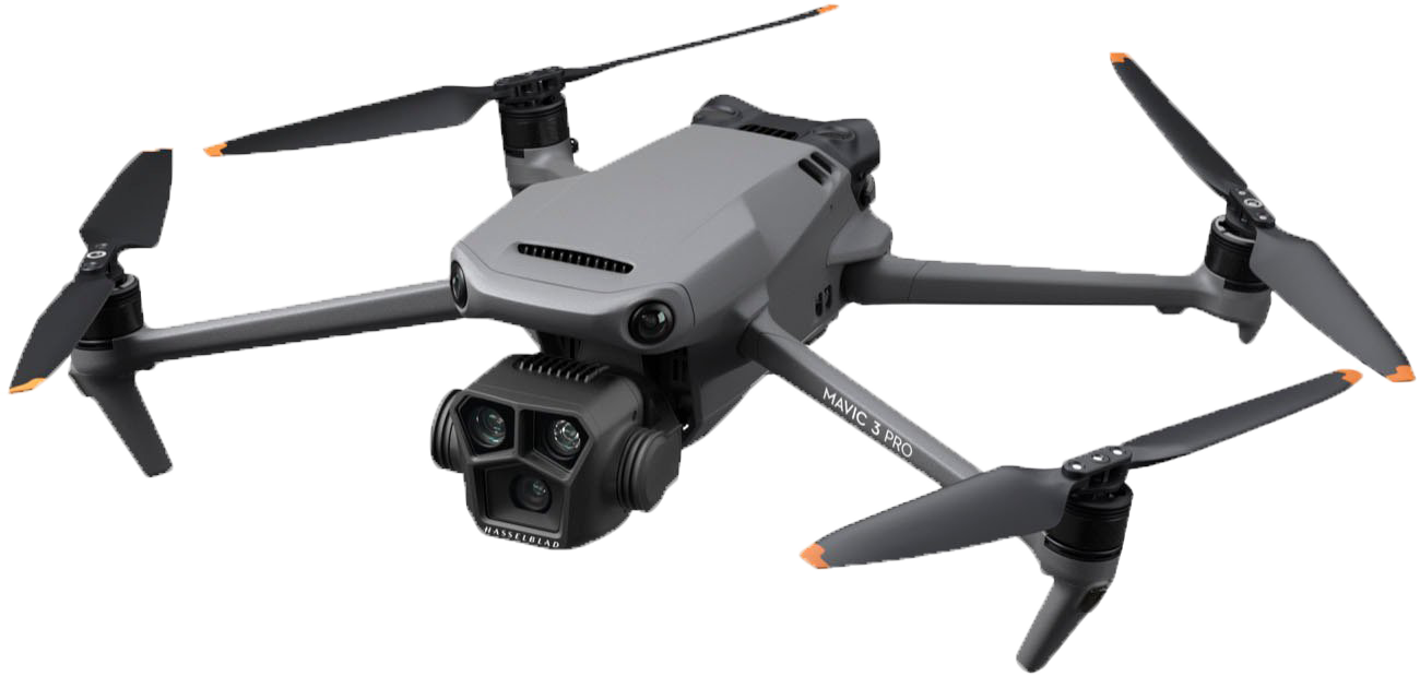
WE DEPLOY THE BEST HARDWARE IN ALL FLIGHT OPERATIONS
we use the dji mavic 3 pro
We use a 5.1k camera for data collection & projects
Construction in the Valley of Phoenix is very abundant. At Eye In The Sky Services, we use the best equipment available to deliver high-end imagery and accurate data collected from all flight operations
Drone mapping made easy
Mapping Made Simple: High-Flying Accuracy, Ground-Level Results
Drone mapping can be less invasive compared to traditional surveying methods. Drones can collect data with minimal disturbance to the environment, making them a more sustainable option for certain types of projects.
In summary, drone mapping provides a modern, efficient, and cost-effective approach to capturing and analyzing spatial data. Its benefits extend across accuracy, speed, cost savings, and versatility, making it an invaluable tool for a wide range of applications and industries.
Our Drone Mapping Packages
we will beat any rate!
show us our competitor's quote on any service and we will quote you up to 10% less.
Display your property with style using professional Zillow Ready High Resolution photos.
call us /we will work with you!!
- Area Coverage: Up to 10 acres
- Resolution: 5 cm per pixel
- Deliverables: Orthomosaic map, 2D contour lines, and basic elevation data
- Delivery 3 - 5 business days
- Includes: One site visit, basic data processing, and quality assurance
The common choice of Real Estate Professionals who post listings on a daily basis.
call us /we will work with you!!
- Area Coverage: Up to 25 acres
- Resolution: 3 cm per pixel
- Deliverables: Orthomosaic map, 2D and 3D contour lines, detailed elevation data, and site analysis
- Delivery: Digital download + USB drive
- Delivery 3 - 5 business days
- Includes: Two site visits, advanced data processing, and custom color mapping
Real estate agents often use drones for big property ads to show impressive pictures and videos and use these features to close deals quickly.
call us /we will work with you!!
- Area Coverage: Up to 50 acres
- Resolution: 2 cm per pixel
- Deliverables: Orthomosaic map, 2D and 3D contour lines, comprehensive elevation data, volumetric analysis, and site planning tools
- Delivery: Digital download + USB drive + Interactive web map
- Delivery 5 business days
- Includes: Multiple site visits, advanced processing, and detailed reporting
Professional Aerial Shots
Start Your Awesome Aerial Project With Us
Reach out to us for any questions you have for your business projects that require aerial services. We guarantee any quote you received prior to speaking to us will be up to 10 % less than what our competitors provided for you.
