Aerial inspections
aerial videography documents data in professional editing and epic finalized media
We offer the best!
Eye In The Sky Services specializes in providing high-quality aerial photography to give you a unique perspective on your projects. Whether you’re showcasing real estate, documenting events, or enhancing marketing materials, our state-of-the-art drone technology and professional services ensure exceptional results.
Aerial Inspection Services with us
Mapping the World from Above, Accurately and Efficiently
Revolutionize Your Inspection Process with Cutting-Edge Drone Technology
Aerial inspections are transforming the way we assess and monitor assets and infrastructure. By harnessing the power of advanced drone technology, aerial inspections provide a comprehensive, high-resolution view of hard-to-reach or expansive areas, offering unparalleled accuracy and efficiency.
What are Aerial Inspections?
Aerial inspections involve using drones equipped with high-definition cameras and sensors to capture detailed images and data from above. These aerial perspectives allow for thorough inspections of structures, infrastructure, and environments without the need for traditional scaffolding or manual access methods.
Why Choose Aerial Inspections?
**1. Enhanced Safety: Aerial inspections minimize the need for personnel to work at heights or in hazardous environments, significantly reducing safety risks.
**2. Comprehensive Coverage: Drones can cover large areas quickly and efficiently, providing a complete view of the inspection site in a fraction of the time required for traditional methods.
**3. High-Resolution Data: Equipped with advanced cameras and sensors, drones capture high-resolution images and videos that reveal intricate details and potential issues that might be missed from the ground.
**4. Cost-Effective: By reducing the need for scaffolding, cranes, or manual inspections, aerial inspections lower overall costs and minimize downtime.
**5. Real-Time Insights: Live video feeds and real-time data transmission allow for immediate analysis and quicker decision-making.
How Do Aerial Inspections Work?
Planning: We begin by understanding your inspection requirements and planning the optimal flight path to ensure thorough coverage and accurate data capture.
Flight Operations: Our certified drone pilots execute the flight plan, capturing high-resolution images and video footage from the required angles and perspectives.
Data Processing: The collected data is processed and analyzed using specialized software to generate detailed reports, including annotated images, video footage, and any identified issues or anomalies.
Reporting: We deliver comprehensive inspection reports that include high-quality visuals, analysis, and recommendations for maintenance or repairs if needed.
Applications of Aerial Inspections
- Infrastructure: Inspect bridges, towers, power lines, and pipelines to assess their condition and detect potential issues.
- Buildings: Examine roofs, facades, and other hard-to-reach areas to identify damage, wear, or maintenance needs.
- Construction Sites: Monitor progress, verify compliance with plans, and inspect safety conditions.
- Energy Sector: Inspect wind turbines, solar panels, and other energy infrastructure for performance and maintenance needs.
- Environmental Monitoring: Assess natural environments and track changes or damage to ecosystems.
We use the best media editing/ 3d modeling/mapping software



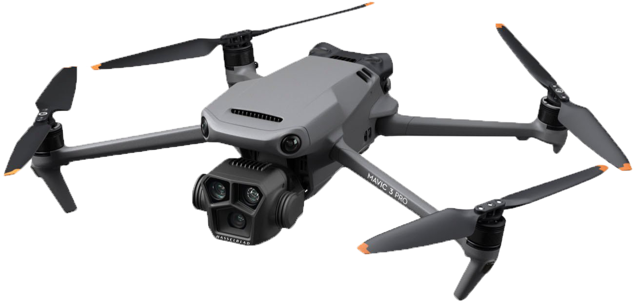
WE DEPLOY THE BEST HARDWARE IN ALL FLIGHT OPERATIONS
we use the dji mavic 3 pro
we only use 5.1k cameras for construction projects
Construction in the Valley of Phoenix is very abundant. At Eye In The Sky Services, we use the best equipment available to deliver high-end imagery and accurate data collected from all flight operations
Drone Inspection Services
Revolutionize Your Inspections with Cutting-Edge Drone Technology
At Eye In The Sky Services, we elevate the standard of inspections with our advanced drone technology. Our drone inspection services provide accurate, efficient, and cost-effective solutions for various industries, ensuring you get the critical insights you need with minimal disruption.
aerial inspection rates
we will beat any rate!
show us our competitor's quote on any service and we will quote you up to 10% less.
General building or small infrastructure
call us /we will work with you!!
- Coverage: Up to 5,000 square feet
- Resolution: 5.1K
- Deliverables: High-resolution photos, basic video footage, and a summary report
- Data & media delivery 3-5 business days
- Delivery: Digital download
- Includes: One site visit, basic data capture, and preliminary analysis
Medium to large buildings or infrastructure
call us /we will work with you!!
- Coverage: Up to 10,000 square feet
- Resolution: 5.1k Ultra HD
- Deliverables: High-resolution photos, detailed video footage, and a comprehensive inspection report with annotated images
- Data & media delivery: Digital download + USB drive
- Delivery 3 - 5 business days
- Includes: Two site visits, detailed data capture, and advanced analysis
Extensive infrastructure or multiple sites
call us /we will work with you!!
- Coverage: Up to 20,000 square feet
- Delivery 5 business days
- Resolution: 5.1k Ultra HD
- Deliverables: High-resolution photos, detailed video footage, 3D model (optional), and an in-depth inspection report with actionable insights
- Delivery: Digital download + USB drive + Interactive web map
- Delivery: Digital download + USB drive + Interactive web map
- Includes: Multiple site visits, advanced data capture, and thorough analysis with expert recommendations
Professional Aerial Shots
Start Your Awesome Aerial Project With Us
Reach out to us for any questions you have for your business projects that require aerial services. We guarantee any quote you received prior to speaking to us will be up to 10 % less than what our competitors provided for you.
